FAIRPORT, PAINESVILLE & EASTERN
MAPS
Railroad maps are great for
giving perspective—both historical and operational—and so to me they are very
valuable. The first map of the FP&E
I collected was on a visit to the Yard Office back in 1983, when the Yardmaster
was nice enough to give me a photocopy of the system map that the employees
used. It was just a black-and-white,
line-drawing style map on a couple of legal-sized pieces of paper, but for me
it was a treasure; for years it was the most important item I had in my small
collection of railroad materials. About
25 years later I finally came across another FP&E map: it was a
blueprint-style system map from about 1928 that I won on eBay. Since then, I have discovered more FP&E
maps, including another system map that was included in the FP&E entry of
some older editions of The Official Railway Equipment Register, as well
as numerous maps that are part of the ICC records at the National Archives.
Below I
present four FP&E system maps with some commentary about each one. After you look over these maps, make sure to
read the "Other Maps" section further below to learn about other
kinds of FP&E-related maps that are available to view on the internet.
System Maps
Circa
1925-1926
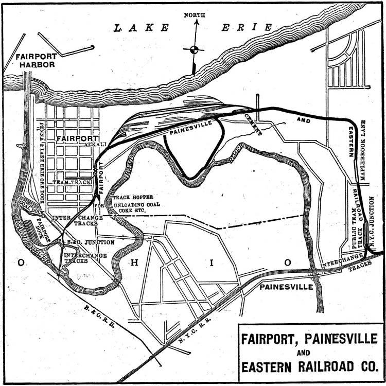
This map
appears in The Official Railway Equipment Register editions from 1926
and 1927. The reason I have dated this
map 1925-26 is because it is after the Diamond's cement plant was completed in
1925 (see my Diamond
Alkali/Shamrock page for details), but before the FP&E's
roundhouse/turntable and yard facility were constructed in 1926 (see my FP&E
History page for details).
Circa
1928
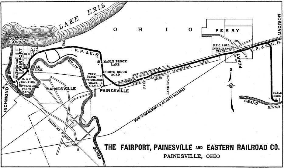
This map
appears in The Official Railway Equipment Register editions from 1928
until 1931. This is basically the same
as the blueprint-style map I won on eBay, but since that map is 22" wide
and in color, it was easier to scan and present this smaller, black-and-white
version here. The reason I have dated
this map 1928 is because it is after the FP&E's roundhouse/turntable and
yard facility were constructed, but before the spur to the shale beds was
deemed unfeasible (as discussed in my FP&E History
page). An interesting thing to note is
the "wishful thinking" the map's designer had: all the blocks of land
marked "Industrial Sites" never really materialized—only two
industries established themselves on this section of the line, but they were
both near Perry and they were both established several decades after this map
was created.
February 1932
(Click on map to see it full-sized)
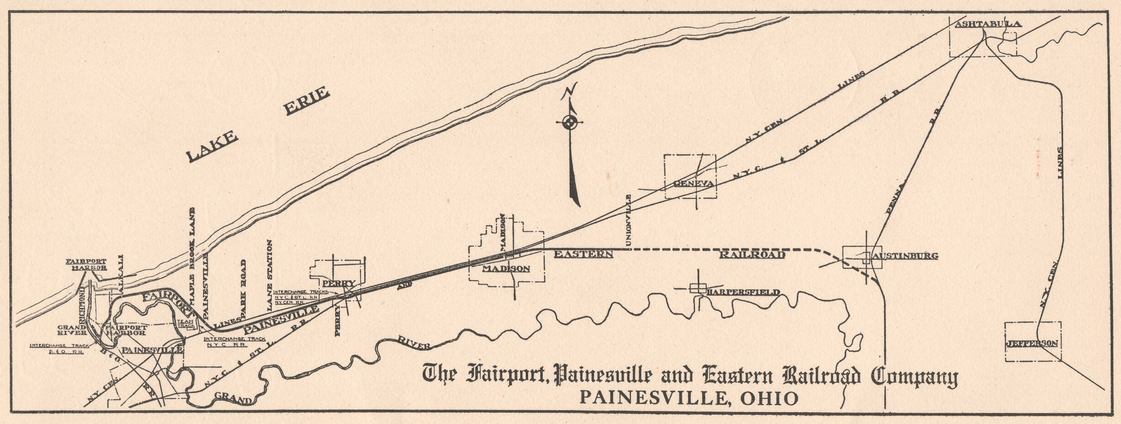
This map
appears on the back of the FP&E's only Employee Time Table, published on
February 1, 1932 (a transcript of which can be seen on my FP&E Time Table
page). There are two key things to
notice on this map: it shows the furthest that the railroad progressed eastward
(just beyond Unionville) and, using a dashed line, it shows the path that the
FP&E would have taken to connect to the Pennsylvania Railroad's PY&A
Branch if the ICC had allowed it (see my FP&E History page for
more details). According to valuation
maps I've seen, the FP&E connection to the PRR would have been right at the
north end of Austinburg Yard, at approximately milepost 116.5.
June 1966
(Click on map to see it full-sized)
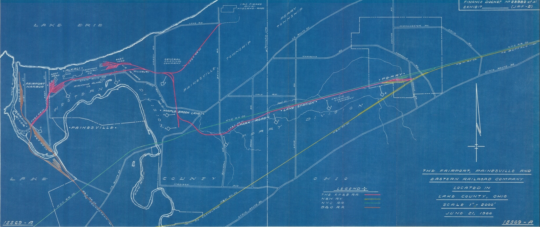
This is
the system map that was presented in ICC Finance Dockets 23980 & 23981 (the
case where Norfolk & Western and New York Central fought over control of
the FP&E). This map was the basis of
the employee map I was given in 1983; it was exciting to find out that the
original version of the map I had treasured for so long was actually created
the year I was born—and that it was in color!
I was
able to get copies of this map from two sources: Randall Jackson (whom I
discuss on my FP&E
Operations page) and the National Archives (which I discuss on my FP&E Resources page). If you would like to get your own full-sized
reproduction, the easiest way is to contact a vendor who specializes in
duplicating maps from the National Archives (a list of approved vendors is
provided on the National Archives website here). If you contact a vendor, this is the citation
you will need to give them:
National Archives Textual Branch Doc. NWCT-134,
[150/82/30/4] Box 3999 - ICC Finance Docket 23980 / Vol.II: Fairport
Painesville & Eastern Map 15569-A / Lake OH (21 Jun 1966)
Other Maps
Valuation Maps
Railroad
valuation maps are very precise survey maps that show every detail of a
railroad's track and property, segment by segment; like other railroads, the
FP&E had to draw up and send valuation maps to the Interstate Commerce
Commission—and these maps are now at the National Archives (along with all the
other ICC records). Getting copies of
the maps is not easy: you either have to go to the Archives in person to make
the necessary copies or you need to hire a researcher to do the work for
you. On top of the difficulty in gaining
access to the maps is the added difficulty of dealing with the sizes of the
maps: they are too big to be copied or scanned on normal equipment, so most likely
you will have to take pictures of the maps with a camera (which is what a
researcher did for me). For those of you
willing to spend the money, you can learn more about the National Archives
and/or hiring a researcher on my FP&E Resources
page (FYI: the valuation maps for the FP&E are filed with Valuation Docket
474).
Although they
are not in the same league as the full-color valuation maps at the National
Archives, there are some FP&E valuation maps available for viewing on the
official Lake County website. The maps
are black-and-white versions and do not show very much in the way of track
details (mainly because these maps are larger in scale than the typical ICC
valuation map)—but I think they are still worth looking at. To view the maps, go here, click on "Railroad Valuation Maps," then
click on "Individual Pdfs."
There are 6 maps for the FP&E, and I have written the following
quick guide/commentary for them:
These four files/maps show the
FP&E circa 1928:
"fpe rr1.pdf" = Western
Division (NYC connection at Painesville to B&O connection at Fairport)
"fpe rr2.pdf" = Perry
Division (NYC connection at Painesville to Perry)
"fpe rr.pdf" = Perry
Division (Perry to Madison Township)
"fpe
rr4.pdf" = Close-up of the beginning of the Perry Division
The first three maps taken together form a 'geographically
correct' version of the 1928 system map shown above. You will notice in these maps that the
FP&E divided their line into two divisions—the Western Division and the
Perry Divison—and that they had separate mile markers for each division. Although later "milepost 0" for the
Western Division was Grand River Station (as shown on the 1966 system map),
according to the mile markers on these maps the beginning point was the NYC
connection in Painesville. Another
interesting thing to note is that a lot of the property on the Perry Division
that the FP&E bought originally belonged to the Cleveland, Painesville
& Ashtabula interurban transit line.
These next two files/maps show a
'swap' of property between the FP&E and Diamond Alkali in 1937:
"FPOE RR.pdf" -
property the FP&E conveyed to Diamond Alkali
"fpe rr3.pdf" -
property Diamond Alkali conveyed to FP&E
These maps illustrate how the FP&E realigned their main
line—something I mention briefly on my FP&E History page.
Tax Maps
The official Lake County website
also has tax maps for the entire county, which show property ownership
boundaries, names and dates. There are no
track details, but again these maps are neat to look at. To view these maps, go here. On the webpage, click "Lake Navigator
3.0"; when the new webpage opens, at the top of the webpage click
"Archived Tax Map." Another
new webpage will open; at the bottom select a volume in the Volume field, enter
a page in the Page field, then click the "Search" button. The result will be both current and older
maps of a specific area in Lake County available to view.
Now you may ask, "Scott, how
do I know what volume and page to put in the fields?" Well, I happen to have listed below each and
every volume/page combination that the FP&E shows up in. The left-hand alpha-numeric code is the
volume, the right-hand number is the page.
So now go have some fun!
FP&E Western Division (from
west to east):
14A 24
14A 23
14A 22
14A 26
12A 59
12A 54
12A 53
12A 51
12A 52
11B 40
11B 42
11B 39
11B 38
11B 29
FP&E Perry Division (from west to east):
11B 29
11B 30
11B 31
11B 32
11B 33
3A 4
3A 12
3A 11
3A 18
3A 17
3A 26
4A 35
3A 34
4A 44
4A 43
3A 43
4A 53
4A 52
3A 52
3A 63
3A 72
3A 82
3A 81
1A 12
1A 13
1A 5
1A 8
2A 11
2A 12
2A 13
2A 8
2A 6
2A 3
1A 71
1A 68
1A 70
FP&E Rayon Branch (from west to east):
11B 42
11B 43
11B 44
11B 45
11B 46
11B 50
NOAA Maps
The National Oceanic and
Atmospheric Administration has a section of their website devoted to historical
nautical charts of ports all over the United States—including Fairport
Harbor. These maps have great details for
railroad tracks that surround any given port, and Fairport Harbor is no
exception; you can see the western-most portion of the FP&E, and in many of
the maps the western portion of the Diamond Alkali/Shamrock complex. To view these maps, go here. Once the webpage
opens, in the "Title" field type "Fairport Harbor," then
click the "Search" button. The
result will be a list of charts of Fairport Harbor going all the way back to
1901 that you can view and download.
The
following charts will be of most interest for FP&E and Diamond
Alkali/Shamrock 'fans' (it's neat to see the progression of the facilities and
tracks over time in these charts):
|
YEAR |
NOTES |
|
1912 |
|
|
1917 |
Note how the Diamond's dock—built by the
FP&E but then sold to Diamond Alkali after it was |
|
completed in 1917—changed the topography
of the area along the Grand River compared to 1912 |
|
|
1924 |
|
|
1937 |
1935 shows the same details for the Diamond
plant, but doesn't show as much of it as 1937 |
|
1940 |
1943 & 1946 show the same details for
the FP&E and the Diamond as the 1940 map |
|
1956 |
1949 & 1953 are missing tracks that
reappear as they should in 1956; 1959, 1963, 1965 and |
|
1967 all show the same details for the
FP&E and the Diamond as the 1956 map |
|
|
1971 |
|
|
1978 |
|
Enjoy!
Created by Scott Nixon
July 2009
Updated: October 2010, June 2021